Download HarvestChoice indicators in raster and/or tabular formats
Usage
genFile(var, iso3 = "SSA", by = NULL, format = c("csv", "geojson", "tif", "dta", "asc", "rds", "grd"), dir = ".", ...)
Arguments
- var
- character array of indicator codes, passed to
getLayer - iso3
- character array of ISO3 country or region codes, passed to
getLayer - by
- character array of indicator codes to summarize by, passed to
getLayer - format
- output format, one of "csv", "json", "tif", "dta", "asc", "grd", "rds".
- dir
- output directory, default to current working directory
- ...
- any other optional argument passed to
getLayer, e.g.as.class,collapse.
Value
-
character, array of generated file names included in the data package
Description
Package results from getLayer into tabular or spatial raster format.
Also includes README and Tabular Data Package specifications.
Currently supported export formats include CSV (csv), STATA (dta), GeoJSON (geojson),
GeoTIFF (tif), R raster (grd), RData (rda), ESRI ASCII raster (asc), and netCDF (nc).
Calling genFile(var="bmi", iso3="TZA", format="dta") is equivalent to calling
the convenience method hcapi(var="bmi", iso3="TZA", format="dta").
Details
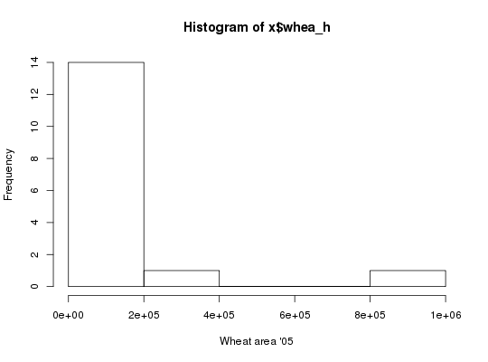
API call: total wheat harvested area across 16 agro-ecological zones in Nigeria and Ethiopia in STATA format
$ curl http://hcapi.harvestchoice.org/ocpu/library/hcapi3/R/genFile \
 -d '{"var" : "whea_h", "iso3" : ["NGA", "ETH"], "by" : "AEZ16_CLAS", "format" : "dta"}' \
 -X POST -H 'Content-Type:application/json'
/ocpu/tmp/x0e654538b7/R/.val /ocpu/tmp/x0e654538b7/stdout /ocpu/tmp/x0e654538b7/warnings /ocpu/tmp/x0e654538b7/source /ocpu/tmp/x0e654538b7/console /ocpu/tmp/x0e654538b7/info /ocpu/tmp/x0e654538b7/files/DESCRIPTION /ocpu/tmp/x0e654538b7/files/README /ocpu/tmp/x0e654538b7/files/whea_h-AEZ16_CLAS-NGA.dta
GET all generated files in a ZIP archive
$ wget http://hcapi.harvestchoice.org/ocpu/tmp/x0e654538b7/zip
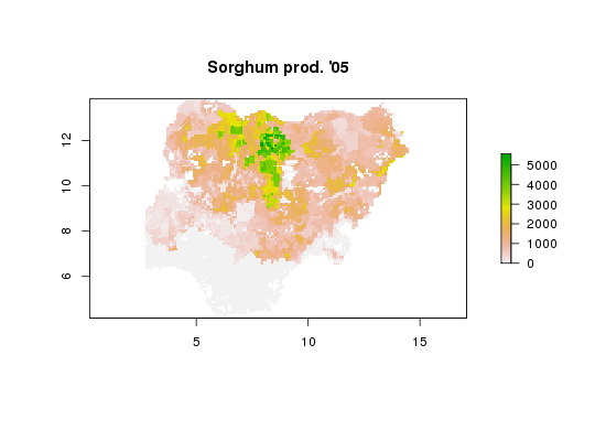
API call: sorghum production in Nigeria in ESRI ASCII raster format
$ curl http://hcapi.harvestchoice.org/ocpu/library/hcapi3/R/genFile \
 -d '{"var" : "sorg_p", "format" : "asc"}' \
 -X POST -H "Content-Type:application/json"
--
/ocpu/tmp/x02a7a044c7/R/.val
/ocpu/tmp/x02a7a044c7/stdout
/ocpu/tmp/x02a7a044c7/warnings
/ocpu/tmp/x02a7a044c7/source
/ocpu/tmp/x02a7a044c7/console
/ocpu/tmp/x02a7a044c7/info
/ocpu/tmp/x02a7a044c7/files/DESCRIPTION
/ocpu/tmp/x02a7a044c7/files/README
/ocpu/tmp/x02a7a044c7/files/sorg_p--SSA.asc
/ocpu/tmp/x02a7a044c7/files/sorg_p--SSA.asc.aux.xml
/ocpu/tmp/x02a7a044c7/files/sorg_p--SSA.prj
GET all generated files in a ZIP archive
$ wget http://hcapi.harvestchoice.org/ocpu/tmp/x02a7a044c7/zip
Examples
# Total wheat harvested area across 16 agro-ecological zones in Nigeria and Ethiopia # in STATA format x <- genFile("whea_h", iso3=c("NGA", "ETH"), by="AEZ16_CLAS", format="dta") # Load generated STATA file require(foreign)Loading required package: foreignx <- read.dta(x[1]) # Plot histogram with full layer title hist(x$whea_h, xlab=vi["whea_h", varLabel]) # Sorghum production in Nigeria in ESRI ASCII raster format x <- genFile("sorg_p", iso3="NGA", format="asc")
x[1] "./hcapi-nga-sorg_p.asc" "./hcapi-nga-sorg_p.asc.aux.xml" [3] "./hcapi-nga-sorg_p.prj" "./meta.csv" [5] "./README.md" "./datapackage.json"# Load and plot generated raster require(raster)Loading required package: raster Loading required package: sp Attaching package: ‘raster’ The following object is masked from ‘package:data.table’: shiftx <- raster(x[1]) plot(x, main=vi["sorg_p", varLabel])
cellStats(x, "mean")[1] 897.064